


STENVENSON Partie 2

pjennes
User

Length
24 km

Max alt
1420 m

Uphill gradient
783 m
Km-Effort
36 km

Min alt
537 m

Downhill gradient
1109 m
Boucle
No
Creation date :
2023-09-18 06:36:19.829
Updated on :
2023-09-19 04:17:58.053
8h39
Difficulty : Difficult

FREE GPS app for hiking
 SityTrail
IGN / Geographical institutes
SityTrail Plus
The world is yours!
About
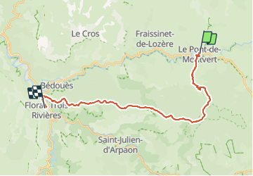
Trail Walking of 24 km to be discovered at Occitania, Lozère, Pont de Montvert - Sud Mont Lozère. This trail is proposed by pjennes.
Description
De PONT DE MINTVERT à FLORAC
Positioning
Country:
France
Region :
Occitania
Department/Province :
Lozère
Municipality :
Pont de Montvert - Sud Mont Lozère
Location:
Unknown
Start:(Dec)
Start:(UTM)
559300 ; 4912484 (31T) N.
Comments